
A U.S. based organization serving the needy of the Philippines since 2005
Frequently Asked Questions
No. Our sole purpose is to provide quality, accessible healthcare.
We are a non-profit organization registered as 501(c)(3) with the U.S. Internal Revenue Service (Employer ID Number 22-3780820). We file a yearly PF-990 form with the IRS, have submitted due diligence documents, and are tax-exempt. All donations go toward the operation of our projects. THERE ARE NO ADMINISTRATION COSTS.
We are registered in Connecticut as a tax-exempt charity CHR.0052790, click here: CTreg.pdf (396.8 KB)
You can help in several ways. First, let your friends and family know about us and what we do. Our main project now and in the near and distant future is the management, maintenance, and operation of the Dr. Jesus A. Datu Medical Center. We rely solely on donations and volunteers. All donations go toward medical equipment, supplies, and daily operational costs. You can assist financially or with supplies and equipment. We are always in need of basic medications and medical and surgical supplies. Check this website and our Facebook page periodically or email us for information on what we currently need.
Please refer to our Donate page on giving options.
Donors can receive regular updates through the website, our Facebook page, or if they wish to provide one, email.
100% of your donation goes toward the actual cause. Everyone is a volunteer and pays his/her own way, which includes travel, food, and lodging. All administrative and fundraising costs and expenses are done on a volunteer basis.
The Foundation was founded by the late Dr. Jesus A. Datu (please refer to the Tribute page of this site) after the Mount Pinatubo eruption in 1991. While based in Subic Bay (Pampanga Province) he personally witnessed the suffering of the local populace and decided to do something about it. What followed were yearly medical missions to the most needy areas of Pampanga, especially the aborigines, the Aetas, and an outflow of year-round donations. It is currently led by his daughter, Dr. Joycelyn A. Datu, also a physician, practicing in Boston, MA and a small staff of volunteers. The main office is in Ledyard, Connecticut, USA.
In 2007, Dr. Jesus Datu realized that yearly medical missions, as helpful as they were, were temporary and fleeting fixtures to a longstanding healthcare problem. He envisioned a non-profit hospital that would provide accessible healthcare to the indigents on a year-round basis. He bought an empty lot in San Vicente, Bacolor, Pampanga owned by the Angeles Family, donated it to the Datu Angeles David Mallari Foundation, and directed that a non-profit hospital dedicated to the indigent population be built there. In April 2008, despite his ill health, he traveled to Bacolor to witness the building’s initial construction. He passed away the next month. The JADMC was completed in December, 2008.
The Love for Life Foundation gave the task of the daily operation of the JADMC to the Kapampangan Development Foundation (KDF), based in the province of Pampanga, which is where the JADMC is located. Led by Mr. Ben Ricafort and under the capable and enthusiastic guidance of Ms. Sylvia Ordonez, they are successfully and rapidly making the JADMC a leader in healthcare not just locally, but throughout southeast Asia.
Tell me more about Bacolor and the Philippines
Bacolor is a municipality in the province of Pampanga, Philippines.
Demographics
Census Pop. Rate:
1990 67,259
1995 13,097 -27.9%
2000 16,147 4.59%
2007 25,238 6.35%
According to the latest census, it has a population of 25,238 people in 3,029 households.
History
Don Guillermo Manabat, a rich landlord, is believed to be the founder of Bacolor.
Historical records show that Bacolor has been in existence as proposed settlement as early as 1571. When the Spaniards under the leadership of Ferdinand Blumentrit arrived they found “Baculud”, its original name meaning level ground because Bacolor was formerly part of the Philippine coastline until eruptions from ancestral Mt. Pinatubo raised it above the ocean floor, on October 1, 1995, the lahar flows from the mountain raised it to its current level of an approximate 37 meters above sea level. Subsidence caused the constant reclaiming of parts of Pampanga by the Sea.
The first settlers of Bacolor were believed to be Malays that came from Atjeth Sumatra led by Panday Pira. It is believed to have been founded by Monmon, first cousin and sister-in-law of Malangsic, a son of Prince Balagtas. However, historians recorded the official foundation of Bacolor to have occurred in 1574 through a landlord named Guillermo Manabat, whose palatial house and resting place is now the site of the San Guillermo Church, hence the church’s name.
The name Baculud was changed to Bacolor when the Spaniards came to the place. It was recorded to have been the first capital of Pampanga for two centuries (1698 to 1904) before San Fernando was declared the capital town of the province in July 1904. In 1757, the provincial building, Casa Real, was constructed at the place where the Bacolor Elementary School is now located.
During the British Occupation of the Philippines, when Manila fell to the British, it became capital of the exiled government of Governor General Simón de Anda y Salazar from October 6, 1762 to May 30, 1764. The provincial offices were temporarily moved to Factoria (now San Isidro, Nueva Ecija). It remained the former capital town of Pampanga until the provincial seat of government was transferred to neighboring City of San Fernando in 1904. Through a decree of the King of Spain on November 9, 1765, Bacolor became “Villa de Bacolor”, one of the only three villas in the Philippines and was granted a Spacial Coat of Arms. Simon de Anda organized an army of natives with which he finally recaptured Manila from the British invaders.
The coming of the American colonizers broke up the military form of government and instead political and economic reforms were introduced. A civil form of government was organized and was inaugurated on February 13, 1901 by Com. William H. Taft which took place in the old “Escuala de Artes y Officios de Bacolor” (formerly named Pampanga School of Arts and Trade) now known as the Don Honorio Technological State University the first state university in Pampanga.
The first provincial Civil Governor was Don Ceferino Joven and the first Municipal President of Bacolor was Don Estanislao Santos. Pampanga was acknowledged as the first province to have organized civil government in the Philippines by General Grant, the then President of the United State of America.
In 1956, the sitio of Mesalipit was converted into a barrio.
On the morning of October 1, 1995, over 20 feet (6.1 m) of lahar from the slopes of Mount Pinatubo and surrounding mountains buried the entire town of Cabalantian among many others, killing hundreds of people. 18 out of the 21 barangays of Bacolor were buried.
Tourism
A landmark in the town is the San Guillermo Parish Church known as the ‘sunken church’ and was one of the structures that was half-buried by the lahar flow. The church has since been renovated and is currently operational and may be accessed through what were once the second floor windows, now converted into doorways. The sunken church and town of Bacolor were used to shoot the 2009 television series May Bukas Pa. The Shrine of Our Lady of Lourdes in Cabetican is also famous for its annual pilgrimage and barrio fiestas.
Bacolor also contains memorials to the Death March Kilometer Posts in Mac Arthur Highway and the oldest trade school in Far East, the Don Honorio Ventura Technological State University.
Bacolor’s festivities are the Feast of San Guillermo and Nuestra Senora del Santissimo Rosario (La Naval) which are celebrated every 10th day of February and 3rd sunday of November, respectively.
Bacolor
Balen Baculud
Municipality
Nickname(s): Villa de Bacolor & of Pampanga for the Literature & Beauty of Women
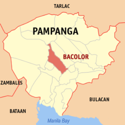
Map of Pampanga showing the location of Bacolor.
The Philippines
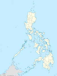
Country: Philippines
Region: Central Luzon (Region III)
Province: Pampanga
District: 3rd District
Founded Barangays: 21
Area
• Total
71.70 km2 (27.68 sq mi)
Population (2007)
• Total
25,238
• Density
351.994/km2 (911.66/sq mi)
The Philippines, officially known as the Republic of the Philippines (Filipino: Republika ng Pilipinas), or in (Spanish: República de las Filipinas) is a sovereign country in Southeast Asia in the western Pacific Ocean. To its north across the Luzon Strait lies Taiwan. West across the South China Sea sits Vietnam. The Sulu Sea to the southwest lies between the country and the island of Borneo, and to the south the Celebes Sea separates it from other islands of Indonesia. It is bounded on the east by the Philippine Sea. Its location on the Pacific Ring of Fire and its tropical climate make the Philippines prone to earthquakes and typhoons but have also endowed the country with natural resources and made it one of the richest areas of biodiversity in the world. An archipelago comprising 7,107 islands, the Philippines is categorized broadly into three main geographical divisions: Luzon, Visayas, and Mindanao. Its capital city is Manila.
With an estimated population of about 94 million people, the Philippines is the world’s 12th most populous country. An additional 11 million Filipinos live overseas. Multiple ethnicities and cultures are found throughout the islands. In prehistoric times, Negritos were some of the archipelago’s earliest inhabitants. They were followed by successive waves of Austronesian peoples who brought with them influences from Malay, Hindu, and Islamic societies. Trade introduced Chinese cultural influences which remain to this day.
The Philippines has been part of several empires: the Spanish Empire during the age of Imperialism, the United States after the Spanish-American War of 1898, and the Japanese Empire during World War II, until the official Philippine independence in 1945.
The arrival of Ferdinand Magellan in 1521 marked the beginning of an era of Spanish interest and eventual colonization. In 1543, Spanish explorer Ruy López de Villalobos named the archipelago Las Islas Filipinas in honor of Philip II of Spain. Miguel López de Legazpi arrived in the Philippines in 1565 and consolidated Spanish rule in the islands, which remained a colony of Spain for more than 300 years.
Manila became the Asian hub of the Manila–Acapulco galleon fleet. Christianity was widely adopted. As the 19th century gave way to the 20th, there followed in quick succession the Philippine Revolution, which spawned the short-lived First Philippine Republic; the Spanish-American War; and the Philippine–American War. In the aftermath, the United States emerged as the dominant power. Aside from the period of Japanese occupation, the United States retained sovereignty over the islands until the end of World War II when the Philippines gained independence. The United States bequeathed to the Philippines the English language and a stronger affinity for Western culture. Since independence the Philippines has had an often tumultuous experience with democracy, with popular “people power” movements overthrowing a dictatorship in one instance but also underlining the institutional weaknesses of its constitutional republic in others.

Bacolor (images courtesy of Judgefloro)
Republic of the Philippines

Flag
Motto: Maka-Diyos, Maka-Tao, Makakalikasan, at Makabansa
(“For God, People, Nature, and Country”)
Anthem: Lupang Hinirang
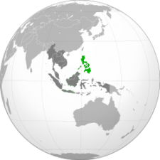
Location of Philippines
Capital: Manila
Largest city: Quezon City
Languages:
Official language(s): Filipino (Tagalog), English
National language: Filipino
Optional languages: Spanish and Arabic
Demonym: Filipino/Filipina
Government: Unitary presidential constitutional republic
Legislature Congress:
– Upper house Senate
– Lower house House of Representatives
Independence:
– Established April 27, 1565
– Declared June 12, 1898
– Self-government March 24, 1934
– Recognized July 4, 1946
– Current constitution February 2, 1987
Area:
– Land 299,764 km2 [2](72nd)
115,831 sq mi
– Water (%) 0.61%[4] (inland waters)
Population:
– 2010 estimate 94,013,200 (12th)
– 2007 census 88,574,614
– Density 306.6/km2 (43rd) 794.1/sq mi
GDP (PPP) 2011 estimate:
– Total $394.0 billion (32nd)
– Per capita $4,111 (125th)
GDP (nominal) 2011 estimate:
– Total $216.096 billion (45th)
– Per capita $2,255 (124th)